AGW Observer

Observations of anthropogenic global warming

Archive for February, 2012

New research from last week 8/2012

Posted by Ari Jokimäki on February 27, 2012

You know those that claim global warming has stopped? Well, it seems that they are talking about boreal winter only.

You know the climate models that can’t do anything right? Well, it seems that they should put tails on them.

You know that the global warming has happened before? Well, it seems that also mass extinctions have happened before.

We also have studies on Himalayan glaciers, Central America climate change rate, extreme weather in China, Russian 2010 heat wave, wind power density, Miocene climate optimum, Turkey corn, and climate sensitivity. Question of the week is: Do kangaroos in Australia affect the temperature trends?


Recent lapse in global warming is just a boreal winter thing

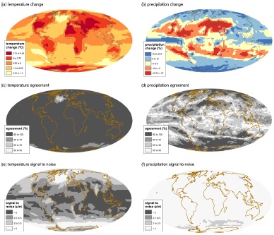
Asymmetric seasonal temperature trends – Cohen et al. (2012) [FULL TEXT]

Abstract: “Current consensus on global climate change predicts warming trends driven by anthropogenic forcing, with maximum temperature changes projected in the Northern Hemisphere (NH) high latitudes during winter. Yet, global temperature trends show little warming over the most recent decade or so. For longer time periods appropriate to the assessment of trends, however, global temperatures have experienced significant warming trends for all seasons except winter, when cooling trends exist instead across large stretches of eastern North America and northern Eurasia. Hence, the most recent lapse in global warming is a seasonal phenomenon, prevalent only in boreal winter. Additionally, we show that the largest regional contributor to global temperature trends over the past two decades is land surface temperatures in the NH extratropics. Therefore, proposed mechanisms explaining the fluctuations in global annual temperatures should address this apparent seasonal asymmetry.”

Citation: Cohen, J. L., J. C. Furtado, M. Barlow, V. A. Alexeev, and J. E. Cherry (2012), Asymmetric seasonal temperature trends, Geophys. Res. Lett., 39, L04705, doi:10.1029/2011GL050582.


Long probability distribution tails complicate model estimates of temperature extremes

Long tails in regional surface temperature probability distributions with implications for extremes under global warming – Ruff & Neelin (2012) [FULL TEXT]

Abstract: “Prior work has shown that probability distributions of column water vapor and several passive tropospheric chemical tracers exhibit longer-than-Gaussian (approximately exponential) tails. The tracer-advection prototypes explaining the formation of these long-tailed distributions motivate exploration of observed surface temperature distributions for non-Gaussian tails. Stations with long records in various climate regimes in National Climatic Data Center Global Surface Summary of Day observations are used to examine tail characteristics for daily average, maximum and minimum surface temperature probability distributions. Each is examined for departures from a Gaussian fit to the core (here approximated as the portion of the distribution exceeding 30% of the maximum). While the core conforms to Gaussian for most distributions, roughly half the cases exhibit non-Gaussian tails in both winter and summer seasons. Most of these are asymmetric, with a long, roughly exponential, tail on only one side. The shape of the tail has substantial implications for potential changes in extreme event occurrences under global warming. Here the change in the probability of exceeding a given threshold temperature is quantified in the simplest case of a shift in the present-day observed distribution. Surface temperature distributions with long tails have a much smaller change in threshold exceedances (smaller increases for high-side and smaller decreases for low-side exceedances relative to exceedances in current climate) under a given warming than do near-Gaussian distributions. This implies that models used to estimate changes in extreme event occurrences due to global warming should be verified regionally for accuracy of simulations of probability distribution tails.”

Citation: Ruff, T. W. and J. D. Neelin (2012), Long tails in regional surface temperature probability distributions with implications for extremes under global warming, Geophys. Res. Lett., 39, L04704, doi:10.1029/2011GL050610.


Global warming possibly one cause for Permian–Triassic mass extinction

Climate warming in the latest Permian and the Permian–Triassic mass extinction – Joachimski et al. (2012)

Abstract: “High-resolution oxygen isotope records document the timing and magnitude of global warming across the Permian-Triassic (P-Tr) boundary. Oxygen isotope ratios measured on phosphate-bound oxygen in conodont apatite from the Meishan and Shangsi sections (South China) decrease by 2‰ in the latest Permian, translating into low-latitude surface water warming of 8 °C. The oxygen isotope shift coincides with the negative shift in carbon isotope ratios of carbonates, suggesting that the addition of isotopically light carbon to the ocean-atmosphere system by Siberian Traps volcanism and related processes resulted in higher greenhouse gas levels and global warming. The major temperature rise started immediately before the main extinction phase, with maximum and harmful temperatures documented in the latest Permian (Meishan: bed 27). The coincidence of climate warming and the main pulse of extinction suggest that global warming was one of the causes of the collapse of the marine and terrestrial ecosystems. In addition, very warm climate conditions in the Early Triassic may have played a major role in the delayed recovery in the aftermath of the Permian-Triassic crisis.”

Citation: Michael M. Joachimski, Xulong Lai, Shuzhong Shen, Haishui Jiang, Genming Luo, Bo Chen, Jun Chen and Yadong Sun, Geology, v. 40 no. 3 p. 195-198, doi: 10.1130/G32707.1.


Himalayan glaciers have gotten darker

Darkening of the mid-Himalaya glaciers since 2000 and the potential causes – Ming et al. (2012) [FULL TEXT]

Abstract: “Himalayan glaciers are a vital water source for people in the high regions of Asia. Their complete melting would be a crisis for approximately 1 billion people. Albedo is one of the key parameters that affect the energy balance of the snow and ice surfaces. Since 2000, albedos have been retrieved from satellite data for eleven representative Himalayan glaciers. It was found that most of the glaciers showed declining trends in the albedo of their upper areas, indicating that they have generally become darker in the past decade. A simulation case study in conjunction with in situ measurements showed that light-absorbing constituents (e.g., black carbon and dust) could be partly responsible for this phenomenon during late springtime; the background regional warming could also be responsible. The current surface radiation absorption in Himalayan glaciers could lead to significant melting, causing most of them to be in danger of rapid mass loss.”

Citation: Jing Ming et al 2012 Environ. Res. Lett. 7 014021 doi:10.1088/1748-9326/7/1/014021.


In 86,000 year temperature record from Central America no climate change matches the rate of current one

Rapid climate change and no-analog vegetation in lowland Central America during the last 86,000 years – Correa-Metrio et al. (2012)

Abstract: “Glacial–interglacial climate cycles are known to have triggered migrations and reassortments of tropical biota. Although long-term precessionally-driven changes in temperature and precipitation have been demonstrated using tropical sediment records, responses to abrupt climate changes, e.g. the cooling of Heinrich stadials or warmings of the deglaciation, are poorly documented. The best predictions of future forest responses to ongoing warming will rely on evaluating the influences of both abrupt and long-term climate changes on past ecosystems. A sedimentary sequence recovered from Lake Petén-Itzá, Guatemalan lowlands, provided a natural archive of environmental history. Pollen and charcoal analyses were used to reconstruct the vegetation and climate history of the area during the last 86,000 years. We found that vegetation composition and air temperature were strongly influenced by millennial-scale changes in the North Atlantic Ocean. Whereas Greenland warm interstadials were associated with warm and relatively wet conditions in the Central American lowlands, cold Greenland stadials, especially those associated with Heinrich events, caused extremely dry and cold conditions. Even though the vegetation seemed to have been highly resilient, plant associations without modern analogs emerged mostly following sharp climate pulses of either warmth or cold, and were paralleled by exceptionally high rates of ecological change. Although pulses of temperature change are evident in this 86,000-year record none matched the rates projected for the 21st Century. According to our findings, the ongoing rapid warming will cause no-modern-analog communities, which given the improbability of returning to lower-than-modern CO2 levels, anthropogenic barriers to migration, and increased anthropogenic fires, will pose immense threats to the biodiversity of the region.”

Citation: Alexander Correa-Metrio, Mark B. Bush, Kenneth R. Cabrera, Shannon Sully, Mark Brenner, David A. Hodell, Jaime Escobar, Tom Guilderson, Quaternary Science Reviews, http://dx.doi.org/10.1016/j.quascirev.2012.01.025.


Extreme temperature and extreme rain have increased in southern China

Spatial and temporal changes in extreme temperature and extreme precipitation in Guangxi – Nie et al. (2012)

Abstract: “This study focuses on extreme temperature and extreme precipitation changes in Guangxi Province of south China, which has experienced increased numbers of climate disasters in recent years. In this paper, spatial and temporal changes in extreme temperature and extreme precipitation were reconstructed for the period 1960–2009. The method of FFT filtering was used to smooth time series of extreme temperature and extreme precipitation, linear regression to calculate linear fits, and spline interpolation to interpolate station data and estimate linear changes. The results show that the annual extreme temperature increased in most of the area during 1960–2009, especially in the northeast. The greatest increase was in the extreme temperature in winter, compared to that in autumn, summer and spring in order from high to low across most of the study area. The annual extreme precipitation changed little in the first three decades and increased significantly in the last two decades, and varied with region and season. Spatially, the annual trend of extreme precipitation increased across most of the province, except in some areas of the southeast. The seasonal change trend of extreme precipitation varied greatly across different areas.”

Citation: Chengjing Nie, Hairong Li, Linsheng Yang, Bixiong Ye, Erfu Dai, Shaohong Wu, Yi Liu, Yongfeng Liao, Quaternary International, http://dx.doi.org/10.1016/j.quaint.2012.02.029.


Anthropogenic warming in southeastern Australia seems to proceed with step changes

Detecting and attributing nonlinear anthropogenic regional warming in southeastern Australia – Jones (2012)

Abstract: “Nonlinear anthropogenic warming is detected and attributed as a series of step changes in observed and simulated climate for southeastern Australia (SEA). A stationary period of 1910–1967 and non-stationary period of 1968–2010 was established using statistically significant step-changes (pH0 < 0.01) in the relationship between observed minimum (Tmin) and maximum (Tmax) temperature (0.6°C in 1968) and Tmax and rainfall (P; 0.7°C in 1997). Regressions between these pairings during stationary conditions were used to determine how Tmin and Tmax would have evolved under non-stationary conditions. Assuming these relationships remain constant, the resulting residuals were attributed to anthropogenic regional warming. This warming was initiated as step changes in 1968 for Tmin (0.7°C) and 1973 for Tmax (0.5°C), coinciding with step changes in zonal (24–44°S) and southern hemisphere mean air temperatures (Tav). A step change in 1997 in Tmax (0.8°C) coincided with a statistically significant step change in global mean air temperature of 0.3°C. This analysis was repeated using regionally averaged output from eleven climate model simulations. Regional warming in all models commenced with step changes in Tmin ranging from 0.4 to 0.7°C between 1964 and 2003. Tmax underwent step changes ranging from 0.7 to 1.1°C simultaneously or within several decades. Further step changes, combined with rising trends, were simulated under increasing radiative forcing to 2100. This highlights limitations in the current use of the signal-to-noise model that considers anthropogenic climate change as a monotonic curve. The identification of multiple step changes in a changing climate provides important information for planning adaptation.”

Citation: Jones, R. N. (2012), Detecting and attributing nonlinear anthropogenic regional warming in southeastern Australia, J. Geophys. Res., 117, D04105, doi:10.1029/2011JD016328.


Russian 2010 heat wave was both natural and anthropogenic in origin

Reconciling two approaches to attribution of the 2010 Russian heat wave – Otto et al. (2012)

Abstract: “In the summer 2010 Western Russia was hit by an extraordinary heat wave, with the region experiencing by far the warmest July since records began. Whether and to what extent this event is attributable to anthropogenic climate change is controversial. Dole et al. (2011) report the 2010 Russian heat wave was “mainly natural in origin” whereas Rahmstorf and Coumou (2011) write that with a probability of 80% “the 2010 July heat record would not have occurred” without the large-scale climate warming since 1980, most of which has been attributed to the anthropogenic increase in greenhouse gas concentrations. The latter explicitly state that their results “contradict those of Dole et al. (2011).” Here we use the results from a large ensemble simulation experiment with an atmospheric general circulation model to show that there is no substantive contradiction between these two papers, in that the same event can be both mostly internally-generated in terms of magnitude and mostly externally-driven in terms of occurrence-probability. The difference in conclusion between these two papers illustrates the importance of specifying precisely what question is being asked in addressing the issue of attribution of individual weather events to external drivers of climate.”

Citation: Otto, F. E. L., N. Massey, G. J. van Oldenborgh, R. G. Jones, and M. R. Allen (2012), Reconciling two approaches to attribution of the 2010 Russian heat wave, Geophys. Res. Lett., 39, L04702, doi:10.1029/2011GL050422.


Wind power density and wind speed decrease in U.S. High Plains during winter and spring

Estimated changes in wind speed and wind power density over the western High Plains, 1971–2000 – Greene et al. (2012)

Abstract: “This manuscript presents the results of research on the temporal patterns in wind speed and wind power density from 1971 to 2000. The study area is across the western High Plains states east of the Rocky Mountains in an area which has a proven wind power resource. Policies and economic analyses involving the rapidly expanding wind power industry have often assumed a constant in the wind resource; however, any temporal pattern or trend in wind speeds can have a meaningful impact on the reliability of wind power as an energy resource. Using data provided by the North American Regional Climate Change Assessment Program (NARCCAP) to analyze decadal and seasonal trends of wind data, this study shows that from 1971 to 2000 there were some notable changes in the NARCCAP simulated wind velocities over the study region. Wind speed trends across the central High Plains of the USA were most notable across the western portion of the study area along the higher terrain near the front range of the Rocky Mountains. The most significant changes occurred during winter and spring when a large portion of the study area experienced the most substantial decrease in wind speed, with a 20% reduction in wind power density during spring across the western portion of the study area. During summer and fall, the trends are less noticeable, with only very small changes in the summer. Fall was the only season that saw widespread increased values of wind power density from the 1970s to 1990s, with increases of nearly 10% in some southern areas of the study area. Based upon the analysis of the data and previous literature, it is theorized that these changes could be the result of changing synoptic patterns across the study region.”

Citation: J. Scott Greene, Matthew Chatelain, Mark Morrissey and Steve Stadler, Theoretical and Applied Climatology, DOI: 10.1007/s00704-012-0596-z.


Model shows far less ocean warming than proxies show during Miocene climatic optimum

Modeling the Miocene climatic optimum: Ocean circulation – Herold et al. (2012)

Abstract: “Ocean circulation is investigated using the Community Climate System Model 3 (CCSM3) forced with early to middle Miocene (∼20–14 Ma) topography, bathymetry, vegetation and modern CO2. Significant bottom water formation is modeled in the Weddell Sea along with intermediate North Component Water formation in the North Atlantic. This is attributed primarily to stronger- and weaker-than-modern convective preconditioning in the Weddell and Labrador Seas, respectively. Global meridional overturning and gyre circulation is weaker in the Miocene due to weaker midlatitude westerlies in the southern hemisphere, caused by lowering of the meridional surface temperature gradient, in addition to regional influences on convection. Subsurface temperatures in the Miocene are significantly higher in the far North Atlantic, Greenland-Norwegian Seas and Arctic basin compared to the present. Ocean heat transport is symmetrical about the equator and resembles that simulated for late Cretaceous and early Cenozoic climates, suggesting the northern hemisphere dominated ocean heat transport active today developed after the middle Miocene. Simulated deep water warming in the Miocene is more than an order of magnitude lower than indicated by proxies. This discrepancy is not reconciled by higher CO2 due to the persistence of sea-ice at sites of deep water formation. This suggests that either the CCSM3 is insufficiently sensitive to Miocene boundary conditions, greater greenhouse forcing existed than is currently reconstructed, or that proxy records of warming are exaggerated. Given the diversity of global Miocene proxy records and their near-unanimous estimate of a significantly warmer Earth, the first two options are more likely.”

Citation: Herold, N., M. Huber, R. D. Müller, and M. Seton (2012), Modeling the Miocene climatic optimum: Ocean circulation, Paleoceanography, 27, PA1209, doi:10.1029/2010PA002041.


Corn yield in western Turkey is generally expected to decrease

Evaluation of climate change effects on future corn (Zea mays L.) yield in western Turkey – Durdu (2012)

Abstract: “A comparative performance analysis was studied on well-known drought indices [Standardized Precipitation Index (SPI), Palmer Drought Severity Index (PDSI) and its moisture anomaly index (Orig-Z), self-calibrated Palmer Drought Severity Index (SC-PDSI) and its moisture anomaly index (SC-Z)] to determine the most appropriate index for assessing corn (Zea mays L.) yield in four crop regions (Aydın, Denizli, Afyon, Uşak) in western Turkey and to evaluate the vulnerability of corn production to climate change with future projections provided by the Hadley Centre for Climate Prediction and Research ENSEMBLES project (HadCM3Q0). A series of curvilinear regression-based crop-yield models were developed for each of the crop region based on the drought indices. The crop-yield model that performed best at high-drought risk years was the SC-PDSI in Aydın region and the PDSI in Denizli, Afyon and Uşak regions. The SC-PDSI index in Aydın region described 75.1% of the measured variability. The PDSI index in Denizli Ayfon and Uşak regions explained 69.8, 71.3 and 66.4% of the measured yield variability, respectively. The vulnerability of the corn yield to HadCM3Q0 projections was evaluated for Aydın and Afyon regions due to the resolution of the regional climate model. For the high-drought risk years, the expected decrease in corn yields was 2.1 ton ha−1 in Aydın region and 0.014 ton ha−1 for Afyon region. For the low drought risk years, the crop yield models predicted the expected decrease in corn yield as 0.104 ton ha−1 in Afyon region. However, there was a positive yield response by 0.022 ton ha−1 in Aydın region.”

Citation: Ömer Faruk Durdu, International Journal of Climatology, DOI: 10.1002/joc.3435.


New climate sensitivity estimate is consistent with previous studies

A climate sensitivity estimate using Bayesian fusion of instrumental observations and an Earth System model – Olson et al. (2012) [FULL TEXT]

Abstract: “Current climate model projections are uncertain. This uncertainty is partly driven by the uncertainty in key model parameters such as climate sensitivity (CS), vertical ocean diffusivity (Kv), and strength of anthropogenic sulfate aerosol forcing. These parameters are commonly estimated using ensembles of model runs constrained by observations. Here we obtain a probability density function (pdf) of these parameters using the University of Victoria Earth System Climate Model (UVic ESCM) – an intermediate complexity model with a dynamic three-dimensional ocean. Specifically, we run an ensemble of UVic ESCM runs varying parameters that affect CS, ocean vertical diffusion, and the effects of anthropogenic sulfate aerosols. We use a statistical emulator that interpolates the UVic ESCM output to parameter settings where the model was not evaluated. We adopt a Bayesian approach to constrain the model output with instrumental surface temperature and ocean heat observations. Our approach accounts for the uncertainties in the properties of model-data residuals. We use a Markov chain Monte Carlo method to obtain a posterior pdf of these parameters. The mode of the climate sensitivity estimate is 2.8°C, with the corresponding 95% credible interval ranging from 1.8 to 4.9°C. These results are generally consistent with previous studies. The CS pdf is sensitive to the assumptions about the priors, to the effects of anthropogenic sulfate aerosols, and to the background vertical ocean diffusivity. Our method can be used with more complex climate models.”

Citation: Olson, R., R. Sriver, M. Goes, N. M. Urban, H. D. Matthews, M. Haran, and K. Keller (2012), A climate sensitivity estimate using Bayesian fusion of instrumental observations and an Earth System model, J. Geophys. Res., 117, D04103, doi:10.1029/2011JD016620.


CLASSIC OF THE WEEK: Mitchell (1953)

On the causes of instrumentally observed secular temperature trends – Mitchell (1953) [FULL TEXT]

Abstract: “Three independent studies of city influence are presented. In the first, recent overlapping observations between the New Haven city and airport stations are used to estimate the local city influence which in turn is used to revise the secular station trend. In the second, evidence of negligible city influence but of real climatic change at Blue Hill Observatory since 1890 is discussed. In the third, a statistical study involving 77 stations in the United States, whose temperature records were observationally homogeneous between 1900 and 1940, bears out the prevalence of important city influence in this country. Except in the period of rapid climatic temperature change occurring since about 1890, observed temperature records, with few individual exceptions, are concluded to be very misleading as direct measures of macroclimatic change over periods longer than a few decades. With their use in climatic studies, particularly those extending back of 1900, isolation of the effects of widespread urban development and frequent thermometer relocation is imperative. At average stations in the United States, urban development has contributed local temperature rises at the rate of more than 1F in a century. The influence of very large cities has not been in proportion.”

Citation: Mitchell, J. Murray, 1953, J. Meteor., 10, 244–261, doi: http://dx.doi.org/10.1175/1520-0469(1953)0102.0.CO;2.


When each paper is published, it is notified in AGW Observer Facebook page and Twitter page. Here’s the archive for the research papers of previous weeks. If this sort of thing interests you, be sure to check out A Few Things Illconsidered. They also have a weekly posting containing lots of links to new research and other climate related news.

Posted in Climate science | Leave a Comment »

New research from last week 7/2012

Posted by Ari Jokimäki on February 20, 2012

This week we have studies on brook trouts, Antarctic Peninsula ice surface, cloud fraction, climate variables, wind, North Atlantic, heat waves, methane, China, precipitation, urban heat island, heat stress, Montana lakes, and sea ice.


Warming delays spawning and reduces redd construction for brook trout

Elevated summer temperatures delay spawning and reduce redd construction for resident brook trout (Salvelinus fontinalis) – Warren et al. (2012)

Abstract: “Redd (nest) surveys for resident brook trout (Salvelinus fontinalis) were conducted annually in a mountain lake in northern New York for eleven years with multiple surveys conducted during the spawning season in eight of those years. Repeated surveys throughout the spawning season allowed us to fit an individually-based parametric model and estimate the day of year on which spawning was initiated, reached its midpoint, and ended during each year. Spawning phenology was then assessed relative to (1) mean of maximum daily air temperature and (2) mean of maximum daily water temperature at the lake bottom during summer in each year using a linear model. Elevated temperatures in summer were correlated with a delay in spawning and a reduction in the total number of redds constructed. Increasing the summer mean of maximum daily air temperatures by one degree C delayed spawning by approximately one week and decreased the total number of redds constructed by nearly 65. Lake spawning brook trout select redd sites based on the presence of discharging groundwater that is relatively constant in temperature within and across years, leading to relatively consistent egg incubation times. Therefore, delayed spawning is likely to delay fry emergence, which could influence emergence synchrony with prey items. This work highlights non-lethal and sub-lethal effects of elevated summer temperatures on native resident salmonids in aquatic environments with limited thermal refugia.”

Citation: Dana R. Warren, Jason M. Robinson, Daniel C. Josephson, Daniel R. Sheldon, Clifford E. Kraft, Global Change Biology, DOI: 10.1111/j.1365-2486.2012.02670.x.


Surface is lowering in Antarctic Peninsula ice shelves

Thirty years of elevation change on Antarctic Peninsula ice shelves from multi-mission satellite radar altimetry – Fricker & Padman (2012)

Abstract: “We use data acquired between 1978 and 2008 by four satellite radar altimeter missions (Seasat, ERS-1, ERS-2 and Envisat) to determine multi-decadal elevation change rates (dhi/dt) for six major Antarctic Peninsula (AP) ice shelves. In areas covered by the Seasat orbit (to 72.16oS), regionally-averaged 30-year trends were negative (surface lowering), with rates between -0.03 and -0.16 m a-1. Surface lowering preceded the start of near-continuous radar altimeter operations that began with ERS-1 in 1992. The average rate of lowering for the first 14 years of the period was typically smaller than the 30-year average; the exception was the southern Wilkins Ice Shelf, which experienced negligible lowering between 2000 and 2008, when a series of large calving events began. Analyses of the continuous ERS/Envisat time series (to 81.5o) for 1992-2008 reveal a period of strong negative dhi/dt on most ice shelves between 1992 and 1995. Based on prior studies of regional atmospheric and oceanic conditions, we hypothesize that the observed elevation changes on Larsen C Ice Shelf are driven primarily by firn compaction while the western AP ice shelves are responding to changes in both surface mass balance and basal melt rates. Our time series also show that large changes in dhi/dt can occur on interannual time scales, reinforcing the importance of long time series altimetry to separate long-term trends associated with climate change from interannual to interdecadal natural variability.”

Citation: Fricker, H. A. and L. Padman (2011), Thirty years of elevation change on Antarctic Peninsula ice shelves from multi-mission satellite radar altimetry, J. Geophys. Res., doi:10.1029/2011JC007126, in press.


Cloud fraction in models and in observations

Evaluation of cloud fraction and its radiative effect simulated by IPCC AR4 global models against ARM surface observations – Qian et al. (2012) [FULL TEXT]

Abstract: “Cloud Fraction (CF) is the dominant modulator of radiative fluxes. In this study, we evaluate CF simulated in the IPCC AR4 GCMs against ARM long-term ground-based measurements, with a focus on the vertical structure, total amount of cloud and its effect on cloud shortwave transmissivity. Comparisons are performed for three climate regimes as represented by the Department of Energy Atmospheric Radiation Measurement (ARM) sites: Southern Great Plains (SGP), Manus, Papua New Guinea and North Slope of Alaska (NSA). Our intercomparisons of three independent measurements of CF or sky-cover reveal that the relative differences are usually less than 10% (5%) for multi-year monthly (annual) mean values, while daily differences are quite significant. The total sky imager (TSI) produces smaller total cloud fraction (TCF) compared to a radar/lidar dataset for highly cloudy days (CF > 0.8), but produces a larger TCF value than the radar/lidar for less cloudy conditions (CF < 0.3). The compensating errors in lower and higher CF days result in small biases of TCF between the vertically pointing radar/lidar dataset and the hemispheric TSI measurements as multi-year data is averaged. The unique radar/lidar CF measurements enable us to evaluate seasonal variation of cloud vertical structures in the GCMs. Both inter-model deviation and model bias against observation are investigated in this study. Another unique aspect of this study is that we use simultaneous measurements of CF and surface radiative fluxes to diagnose potential discrepancies among the GCMs in representing other cloud optical properties than TCF. The results show that the model-observation and inter-model deviations have similar magnitudes for the TCF and the normalized cloud effect, and these deviations are larger than those in surface downward solar radiation and cloud transmissivity. This implies that other dimensions of cloud in addition to cloud amount, such as cloud optical thickness and/or cloud height, have a similar magnitude of disparity as TCF within the GCMs, and suggests that the better agreement among GCMs in solar radiative fluxes could be a result of compensating effects from errors in cloud vertical structure, overlap assumption, cloud optical depth and/or cloud fraction. The internal variability of CF simulated in ensemble runs with the same model is minimal. Similar deviation patterns between inter-model and model-measurement comparisons suggest that the climate models tend to generate larger biases against observations for those variables with larger inter-model deviation. The GCM performance in simulating the probability distribution, transmissivity and vertical profiles of cloud are comprehensively evaluated over the three ARM sites. The GCMs perform better at SGP than at the other two sites in simulating the seasonal variation and probability distribution of TCF. However, the models remarkably underpredict the TCF at SGP and cloud transmissivity is less susceptible to the change of TCF than observed. In the tropics, most of the GCMs tend to underpredict CF and fail to capture the seasonal variation of CF at middle and low levels. The high-level CF is much larger in the GCMs than the observations and the inter-model variability of CF also reaches a maximum at high levels in the tropics, indicating discrepancies in the representation of ice cloud associated with convection in the models. While the GCMs generally capture the maximum CF in the boundary layer and vertical variability, the inter-model deviation is largest near the surface over the Arctic.”

Citation: Qian, Y., Long, C. N., Wang, H., Comstock, J. M., McFarlane, S. A., and Xie, S.: Evaluation of cloud fraction and its radiative effect simulated by IPCC AR4 global models against ARM surface observations, Atmos. Chem. Phys., 12, 1785-1810, doi:10.5194/acp-12-1785-2012, 2012.


How to map climate variables and their uncertainties?

Mapping the climate: guidance on appropriate techniques to map climate variables and their uncertainty – Kaye et al. (2012) [FULL TEXT]

Abstract: “Maps are a crucial asset in communicating climate science to a diverse audience, and there is a wealth of software available to analyse and visualise climate information. However, this availability makes it easy to create poor maps as users often lack an underlying cartographic knowledge. Unlike traditional cartography, where many known standards allow maps to be interpreted easily, there is no standard mapping approach used to represent uncertainty (in climate or other information). Consequently, a wide range of techniques have been applied for this purpose, and users may spend unnecessary time trying to understand the mapping approach rather than interpreting the information presented. Furthermore, communicating and visualising uncertainties in climate data and climate change projections, using for example ensemble based approaches, presents additional challenges for mapping that require careful consideration. The aim of this paper is to provide background information and guidance on suitable techniques for mapping climate variables, including uncertainty. We assess a range of existing and novel techniques for mapping variables and uncertainties, comparing “intrinsic” approaches that use colour in much the same way as conventional thematic maps with “extrinsic” approaches that incorporate additional geometry such as points or features. Using cartographic knowledge and lessons learned from mapping in different disciplines we propose the following 6 general mapping guidelines to develop a suitable mapping technique that represents both magnitude and uncertainty in climate data: – use a sensible sequential or diverging colour scheme; – use appropriate colour symbolism if it is applicable; – ensure the map is usable by colour blind people; – use a data classification scheme that does not misrepresent the data; – use a map projection that does not distort the data – attempt to be visually intuitive to understand. Using these guidelines, we suggest an approach to map climate variables with associated uncertainty, that can be easily replicated for a wide range of climate mapping applications. It is proposed this technique would provide a consistent approach suitable for mapping information for the Fifth Assessment Report of the Intergovernmental Panel on Climate Change (IPCC AR5).”

Citation: Kaye, N. R., Hartley, A., and Hemming, D.: Mapping the climate: guidance on appropriate techniques to map climate variables and their uncertainty, Geosci. Model Dev., 5, 245-256, doi:10.5194/gmd-5-245-2012, 2012.


Global warming is one of the factors in wind changes over China

The decreasing wind speed in southwestern China during 1969-2009, and possible causes – Xiaomei et al. (2012)

Abstract: “Daily wind speed data from 110 stations in southwestern China were analyzed to determine trends, spatial differences and possible causes. There was a statistically significant decrease of 0.24m/s per decade in the annual mean wind speed during the period 1969-2009. The decreasing trend was faster (0.37m/s/10a) during 1969-2000. Between 2001 and 2009, there was a significant increase. The pattern of seasonal changes was similar. Stations with stronger, significant decreasing trends were mainly on the Xizang Plateau, the Hengduan Mountains and the Yunnan Plateau, and stations with significant increasing trends were mainly in the Sichuan basin, indicating the influence of altitude on wind speed. Surface wind speeds in southwestern China have been affected in recent years by both the changed large-scale atmospheric circulation and regional and global warming, while the weakening surface pressure gradient between high and low latitudinal regions may be an important contributor to the decreased wind speed under the asymmetric warming during 1969-2009. The data indicated a positive correlation between wind speed and sunshine duration suggesting another possible influencing factor. Topographical influences are evident in the higher annual and seasonal trends at summit and intermontane basin stations and the lower trends at valley stations.”

Citation: Yang Xiaomei, Li Zongxing, Feng Qi, He Yuanqing, An Wenlin, Zhang Wei, Cao Weihong, Yu Tengfei, Wang Yamin, H. Wilfred Theakstone, Quaternary International, http://dx.doi.org/10.1016/j.quaint.2012.02.020.


Model ensamble makes skillful decadal predictions of North Atlantic upper ocean heat content

A Decadal Prediction Case Study: Late 20th century North Atlantic Ocean Heat Content – Yeager et al. (2012) [FULL TEXT]

Abstract: “An ensemble of initialized decadal prediction (DP) experiments using the Community Climate System Model, version 4 (CCSM4) shows considerable skill at forecasting changes in North Atlantic upper ocean heat content and surface temperature up to a decade in advance. Coupled model ensembles were integrated forward from each of 10 different start dates spanning 1961 to 2006 with ocean and sea-ice initial conditions obtained from a forced historical experiment (CORE-IA), which exhibits a good correspondence with late 20th century ocean observations from the North Atlantic subpolar gyre (SPG) region. North Atlantic heat content anomalies from the DP ensemble correlate highly with those from the CORE-IA simulation after correcting for a drift bias. In particular, the observed large, rapid rise in SPG heat content in the mid 1990s is successfully predicted in the ensemble initialized in January of 1991. A budget of SPG heat content from the CORE-IA experiment sheds light on the origins of the 1990s regime shift, and it demonstrates the extent to which low-frequency changes in ocean heat advection related to the Atlantic meridional overturning circulation dominate temperature tendencies in this region. Similar budgets from the DP ensembles reveal varying degrees of predictive skill in the individual heat budget terms, with large advective heat flux anomalies from the south exhibiting the highest correlation with CORE-IA. The skill of the DP in this region is thus tied to correct initialization of ocean circulation anomalies, while external forcing is found to contribute negligibly (and for incorrect reasons) to predictive skill in this region and over this time period.”

Citation: Stephen Yeager, Alicia Karspeck, Gokhan Danabasoglu, Joe Tribbia, and Haiyan Teng, Journal of Climate 2012, doi: http://dx.doi.org/10.1175/JCLI-D-11-00595.1.


Climate change brings more heat waves to North America

A Model Study of Heat Waves over North America: Meteorological Aspects and Projections for the 21st Century – Lau & Nath (2012)

Abstract: “The characteristics of summertime heat waves in North America are examined using reanalysis data and simulations by two general circulation models with horizontal resolution of 50 and 200 km. Several ‘key regions’ with spatially coherent and high-amplitude fluctuations in daily surface air temperature are identified. The typical synoptic features accompanying warm episodes in these regions are described. The averaged intensity, duration and frequency of occurrence of the heat waves in various key regions, as simulated in the two models for 20th-century climate, are in general agreement with the results based on reanalysis data. The impact of climate change on the heat wave characteristics in various key regions is assessed by contrasting model runs based on a scenario for the 21st century with those for the 20th century. Both models indicate considerable increases in the duration and frequency of heat wave episodes, and in number of heat wave days per year, during the 21st century. The duration and frequency statistics of the heat waves in the mid-21st century, as generated by the model with 50-km resolution, can be reproduced by adding the projected warming trend to the daily temperature data for the late-20th century, and then recomputing these statistics. The detailed evolution of the averaged intensity, duration and frequency of the heat waves through individual decades of the 20th and 21st centuries, as simulated and projected by the model with 200-km resolution, indicates that the upward trend in these heat wave measures should become apparent in the early decades of the 21st century.”

Citation: Ngar-Cheung Lau and Mary Jo Nath, Journal of Climate 2012, doi: http://dx.doi.org/10.1175/JCLI-D-11-00575.1.


Terrestrial methane emissions are related to temperature variability

Use of a process-based model for assessing the methane budgets of global terrestrial ecosystems and evaluation of uncertainty – Ito & Inatomi (2012) [FULL TEXT]

Abstract: “We assessed the global terrestrial budget of methane (CH4) by using a process-based biogeochemical model (VISIT) and inventory data for components of the budget that were not included in the model. Emissions from wetlands, paddy fields, biomass burning, and plants, as well as oxidative consumption by upland soils, were simulated by the model. Emissions from ruminant livestock and termites were evaluated by using an inventory approach. These CH4 flows were estimated for each of the model’s 0.5° × 0.5° grid cells from 1901 to 2009, while accounting for atmospheric composition, meteorological factors, and land-use changes. Estimation uncertainties were examined through ensemble simulations using different parameterization schemes and input data (e.g., different wetland maps and emission factors). From 1996 to 2005, the average global terrestrial CH4 budget was estimated on the basis of 1152 simulations, and terrestrial ecosystems were found to be a net source of 308.3 ± 20.7 Tg CH4 yr−1. Wetland and livestock ruminant emissions were the primary sources. The results of our simulations indicate that sources and sinks are distributed highly heterogeneously over the Earth’s land surface. Seasonal and interannual variability in the terrestrial budget was also assessed. The trend of increasing net emission from terrestrial sources and its relationship with temperature variability imply that terrestrial CH4 feedbacks will play an increasingly important role as a result of future climatic change.”

Citation: Ito, A. and Inatomi, M.: Use of a process-based model for assessing the methane budgets of global terrestrial ecosystems and evaluation of uncertainty, Biogeosciences, 9, 759-773, doi:10.5194/bg-9-759-2012, 2012.


After 1990 all temperature indices show significant warming trends throughout China

Changes in the observed trends in extreme temperatures over China around 1990 – Qi & Wang (2012)

Abstract: “Based on the daily temperature data from weather stations in China, linear trends of the seasonal mean and extreme temperatures in summer and winter are analyzed, respectively, and compared for the periods of 1960-1989 and 1990-2009. The results show prominent changes in those trends since early 1990s, in particular in winter, a signal of climate shift as previously identified. The changes, however, are found to be strongly region-dependent. In summer, both the seasonal mean and the extreme temperatures show a considerable cooling trend in Central China and a warming trend in North and South China before 1990. After 1990 all temperature indices show significant warming trends throughout China with the largest trend up to 4.47°C/10yr in North China. In winter regions in North China with the most prominent warming trend during 1960-1989 show a significant cooling trend in both the seasonal mean temperature and the cold temperature indices after 1990. The warming trends over the Tibetan Plateau are substantially enhanced since 1990. All indices for the diurnal temperature range (DTR) show consistent decreasing trends in both summer and winter throughout China before 1990 while they turn to increasing trends in Northeast China in summer and over the Tibetan Plateau in winter after 1990. The annual temperature range (ATR) displays a decreasing trend throughout China before 1990 while it is dominated by an increasing trend after 1990 except over the Tibetan Plateau and in a narrow band along the Yangtze River. Possible mechanisms for the observed trend changes are discussed.”

Citation: Li Qi and Yuqing Wang, Journal of Climate 2012, doi: http://dx.doi.org/10.1175/JCLI-D-11-00437.1.


Seasonal precipitation has changed more than models predict

Changes in seasonal land precipitation during the latter twentieth-century – Noake et al. (2012)

Abstract: “Climate models predict substantial changes in seasonal precipitation in the future. Anthropogenic forcing has been found to contribute to the observed pattern of land precipitation change over the 2nd half of the 20th century when annual precipitation is averaged within latitude bands, the observed change was substantially larger than response simulated in climate models, based on a single observational dataset. Here we investigate the robustness of this finding using several land only observational datasets and look for an explanation for why observed changes are significantly larger. We show the discrepancy between model simulated and observed trends is reduced when changes are expressed as percent climatology, which reduces the difference in scale between observed point locations and model gridboxes. Focusing on seasonal rather than annual data reveals that there are seasonal differences in the pattern of zonal precipitation changes over the 20th century. We use fingerprint for zonal precipitation changes from 54 CMIP3 simulations and show that observed changes are detectable in all seasons but boreal summer (JJA), even when doubling the variance of the model simulation, and irrespective of the dataset used. The observed change is still larger than that simulated by the multi-model mean in all datasets except in boreal summer but only in boreal spring is the observed change robustly and significantly larger than that simulated.”

Citation: Noake, K., D. Polson, G. Hegerl, and X. Zhang (2012), Changes in seasonal land precipitation during the latter twentieth-century, Geophys. Res. Lett., 39, L03706, doi:10.1029/2011GL050405.


Analysing the urban heat island measurement techniques

Relationship of land surface and air temperatures and its implications for quantifying urban heat island indicators—An application for the city of Leipzig (Germany) – Schwartz et al. (2012)

Abstract: “Urban heat islands (UHIs) describe the phenomenon of altered temperatures that occur in urban areas when compared to their rural surroundings. UHIs influence human well-being, human health and the city as an ecological niche. UHIs can be quantified with meteorological ground measurements of air temperatures or with remotely sensed land surface temperatures (surface urban heat island). Both approaches have advantages and disadvantages and are rarely combined. Further, within these approaches, different indicators for quantifying the UHIs are used. In this methodological study, we (1) combined data on land surface and air temperatures, (2) enriched the debate by suggesting the application of indicators for the two distinct data sets and (3) systematically quantified indicators of all approaches for the city of Leipzig, Germany. A relationship between the land surface and air temperatures was established. However, the results for the single indicators showed that the absolute values of the detected UHI in Leipzig depend on the selected indicator and the data set used. The main conclusion for future studies on UHIs is to use several UHI indicators in parallel to acknowledge the uncertainty of measuring the UHI using a single indicator and either ground measurements or remote sensing.”

Citation: Nina Schwarz, Uwe Schlink, Ulrich Franck, Katrin Großmann, Ecological Indicators, http://dx.doi.org/10.1016/j.ecolind.2012.01.001.


There will be lots of hot city nights in the future

Contrasting urban and rural heat stress responses to climate change – Fischer et al. (2012)

Abstract: “Hot temperatures in combination with high humidity cause human discomfort and may increase morbidity and mortality. A global climate model with an embedded urban model is used to explore the urban-rural contrast in the wet-bulb globe temperature, a heat stress index accounting for temperature and humidity. Wet-bulb globe temperatures are calculated at each model time step to resolve the heat stress diurnal cycle. The model simulates substantially higher heat stress in urban areas compared to neighbouring rural areas. Urban humidity deficit only weakly offsets the enhanced heat stress due to the large night-time urban heat island. The urban-rural contrast in heat stress is most pronounced at night and over mid-latitudes and subtropics. During heatwaves, the urban heat stress amplification is particularly pronounced. Heat stress strongly increases with doubled CO2 concentrations over both urban and rural surfaces. The tropics experience the greatest increase in number of high-heat-stress nights, despite a relatively weak ∼2°C warming. Given the lack of a distinct annual cycle and high relative humidity, the modest tropical warming leads to exceedance of the present-day record levels during more than half of the year in tropical regions, where adaptive capacity is often low. While the absolute urban and rural heat stress response to 2 × CO2 is similar, the occurrence of nights with extremely high heat stress increases more in cities than surrounding rural areas.”

Citation: Fischer, E. M., K. W. Oleson, and D. M. Lawrence (2012), Contrasting urban and rural heat stress responses to climate change, Geophys. Res. Lett., 39, L03705, doi:10.1029/2011GL050576.


Diatom records from four Montana lakes show five Late-Holocene climate changes

Synchronous climatic change inferred from diatom records in four western Montana lakes in the U.S. Rocky Mountains – Bracht-Flyr & Fritz (2012)

Abstract: “Late-Holocene environmental and climatic conditions were reconstructed from diatom assemblages in sediment cores from four western Montana lakes: Crevice Lake, Foy Lake, Morrison Lake, and Reservoir Lake. The lakes show synchroneity in timing of shifts in diatom community structure, but the nature of these changes differs among the lakes. Two of the sites provide highly resolved records of hydrologic balance, while the other two stratigraphic sequences primarily record temperature impact on lake thermal structure. All four lakes show significant change in five discrete intervals: 2200–2100, 1700–1600, 1350–1200, 800–600, and 250 cal yr BP. The similarities in the timing of change suggest overlying regional climatic influences on lake dynamics. The 800–600 cal yr BP shift is evident in other paleorecords throughout the Great Plains and western US, associated with the transition from the Medieval Climate Anomaly to the Little Ice Age. Large-scale climatic mechanisms that influence these lake environments may result from atmospheric circulation patterns that are driven by interactions between Pacific and Atlantic sea-surface temperatures, which are then locally modified by topography.”

Citation: Brandi Bracht-Flyr, Sherilyn C. Fritz, Quaternary Research, http://dx.doi.org/10.1016/j.yqres.2011.12.005.


New study finds no irreversible behaviour in the sea ice cover

How reversible is sea ice loss? – Ridley et al. (2012) [FULL TEXT]

Abstract: “It is well accepted that increasing atmospheric CO2 results in global warming, leading to a decline in polar sea ice area. Here, the specific question of whether there is a tipping point in the sea ice cover is investigated. The global climate model HadCM3 is used to map the trajectory of sea ice area under idealised scenarios. The atmospheric CO2 is first ramped up to four times pre-industrial levels (4 × CO2), then ramped down to pre-industrial levels. We also examine the impact of stabilising climate at 4 × CO2 prior to ramping CO2 down to pre-industrial levels. Against global mean temperature, Arctic sea ice area is reversible, while the Antarctic sea ice shows some asymmetric behaviour – its rate of change slower, with falling temperatures, than its rate of change with rising temperatures. However, we show that the asymmetric behaviour is driven by hemispherical differences in temperature change between transient and stabilisation periods. We find no irreversible behaviour in the sea ice cover.”

Citation: Ridley, J. K., Lowe, J. A., and Hewitt, H. T.: How reversible is sea ice loss?, The Cryosphere, 6, 193-198, doi:10.5194/tc-6-193-2012, 2012.


CLASSIC OF THE WEEK: Douglass (1909)

Weather Cycles in the Growth of Big Trees – Douglass (1909) [FULL TEXT]

Abstract: No abstract, but here are the working hypothesis and basic methods of Douglass: “(1) the rings of a tree measure its food supply; (2) food supply depends largely upon the amount of moisture, especially where the quantity of moisture is limited and the life struggle of the tree is against drought rather than against competing vegetation; (3) in such countries, therefore, the rings are likely to form a measure of the precipitation. In planning the work three fundamental steps were anticipated. First, to prepare a curve of tree growth; second, to find if there exists in this any connection with precipitation; third, by carrying this back through long periods to find whether meteorological variations, if discovered, show association with astronomical phenomena.”

Citation: DOUGLASS, A. E., 1909: WEATHER CYCLES IN THE GROWTH OF BIG TREES. Mon. Wea. Rev., 37, 225–237. doi: http://dx.doi.org/10.1175/1520-0493(1909)37%5B225d:WCITGO%5D2.0.CO;2.


When each paper is published, it is notified in AGW Observer Facebook page and Twitter page. Here’s the archive for the research papers of previous weeks. If this sort of thing interests you, be sure to check out A Few Things Illconsidered. They also have a weekly posting containing lots of links to new research and other climate related news.

Posted in Climate science | Leave a Comment »

New research from last week 6/2012

Posted by Ari Jokimäki on February 13, 2012

Michael Mann has been a busy beaver this week – not only is there the book thing he’s doing, but he also managed to get his name on two of the papers here. So, Dr. Mann, with my unanimous decision, you are the scientist of the week!

So the climate warms and Italian trees get their temperature signals all messed up (and even without the help from volcanos) and so does an Antarctic ice core. Playing with carbon cycle models or fiddling with old ocean measurements or counting U.S. temperature records (of which U.S. public probably don’t even care) don’t help. So we get our weather extreme and disaster analysis methods in shape and then we just sit back and wait. It won’t be long wait, though, as the aerosol forcing (from transportation for example) diminishes and GHG warming really starts to kick in fast. That’s air pollution control for you. Speaking about pollution control, we are just glad that British river dwellers are doing little bit better these days, partly due to toxic waste management. In middle all this, we are wondering if solar cycle affects Madden-Julian oscillation and if Bering Sea would get a nice swimming temperature, if we would double the CO2 in the air.


Italian mountain trees are losing their June temperature signal from their rings

Weakening climatic signal since mid-20th century in European larch tree-ring chronologies at different altitudes from the Adamello-Presanella Massif (Italian Alps) – Coppola et al. (2012)

Abstract: “Tree rings from temperature-limited environments are highly sensitive climate proxies, widely used to reconstruct past climate parameters for periods prior to the availability of instrumental data and to analyse the effect of recent global warming on tree growth. An analysis of the climatic signal in five high-elevation tree-ring width chronologies of European larch (Larix decidua Mill.) from the tops of five different glacial valleys in the Italian Central Alps revealed that they contain a strong summer-temperature signal and that tree-ring growth is especially influenced by June temperatures. However, a moving correlation function analysis revealed a recent loss of the June temperature signal in the tree-ring chronologies. This signal reduction primarily involves the two lowest-altitude chronologies. It is probable that the observed increasing importance of late-summer temperature for tree-ring growth over the past 50 yr is an effect of the lengthening growing season and of the variations in the climate/tree-ring relationship over time. All the chronologies considered, especially those at the highest altitudes, show an increasing negative influence of June precipitation on tree-ring growth. The climatic signal recorded in tree-ring chronologies from the Italian Central Alps varies over time and is also differentially influenced by climatic parameters according to site elevation.”

Citation: Anna Coppola, Giovanni Leonelli, Maria Cristina Salvatore, Manuela Pelfini, Carlo Baroni, Quaternary Research, http://dx.doi.org/10.1016/j.yqres.2012.01.004.


Carbon cycle model successfully reproduces CO2 changes through last glacial cycle

Glacial CO2 cycle as a succession of key physical and biogeochemical processes – Brovkin et al. (2012) [FULL TEXT]

Abstract: “During glacial-interglacial cycles, atmospheric CO2 concentration varied by about 100 ppmv in amplitude. While testing mechanisms that have led to the low glacial CO2 level could be done in equilibrium model experiments, an ultimate goal is to explain CO2 changes in transient simulations through the complete glacial-interglacial cycle. The computationally efficient Earth System model of intermediate complexity CLIMBER-2 is used to simulate global biogeochemistry over the last glacial cycle (126 kyr). The physical core of the model (atmosphere, ocean, land and ice sheets) is driven by orbital changes and reconstructed radiative forcing from greenhouses gases, ice, and aeolian dust. The carbon cycle model is able to reproduce the main features of the CO2 changes: a 50 ppmv CO2 drop during glacial inception, a minimum concentration at the last glacial maximum 80 ppmv lower than the Holocene value, and an abrupt 60 ppmv CO2 rise during the deglaciation. The model deep ocean δ13C also resembles reconstructions from deep-sea cores. The main drivers of atmospheric CO2 evolve in time: changes in sea surface temperatures and in the volume of bottom water of southern origin control atmospheric CO2 during the glacial inception and deglaciation; changes in carbonate chemistry and marine biology are dominant during the first and second parts of the glacial cycle, respectively. These feedback mechanisms could also significantly impact the ultimate climate response to the anthropogenic perturbation.”

Citation: Brovkin, V., Ganopolski, A., Archer, D., and Munhoven, G.: Glacial CO2 cycle as a succession of key physical and biogeochemical processes, Clim. Past, 8, 251-264, doi:10.5194/cp-8-251-2012, 2012.


Tackling the issue of limited historical observations of ocean climate

Detecting historical ocean climate variability – Carton et al. (2012)

Abstract: “While ocean observations of temperature and salinity extend back to the 19th century, their observation count, as well as geographical and vertical distributions all changed dramatically between successive decades. Similarly, atmospheric observations were unevenly distributed in space and time. This study explores the usefulness of past oceanic and atmospheric observing systems to detect extreme climate events through a set of observing system simulation experiments. In these experiments an initial simulation of the evolving ocean state during 1995–1998 (Nature Run) is sub-sampled using the same distribution of surface and subsurface observations as exists in successive decades. The result is a set of synthetic ocean observation re-samples of the massive mainly tropical/subtropical climate anomalies of the 1995–1998 years. These synthetic observation re-samples are then assimilated into a general circulation ocean model using a conventional assimilation scheme. In one set of experiments the model used in data assimilation is driven with climatological forcing to mimic the effects of poorly specified surface forcing. The results indicate that prior to the 1940s the historical observing network alone was only able to resolve limited aspects of tropical/subtropical variability. In contrast, by the 1960s the observing system was sufficient to resolve variability without additional wind information. In a second set of assimilation experiments surface meteorological forcing is improved to an extent consistent with meteorological error estimates for past decades. When this historical surface forcing is also included the results suggest that this extreme climate variability is reproducible even back to the early years of the 20th century. The paper concludes with a discussion of the implications of several simplifying assumptions used to obtain these optimistic results.”

Citation: Carton, J. A., H. F. Seidel, and B. S. Giese (2012), Detecting historical ocean climate variability, J. Geophys. Res., 117, C02023, doi:10.1029/2011JC007401.


Overview of statistical methods used for weather extremes and disasters

Inferences on weather extremes and weather-related disasters: a review of statistical methods – Visser & Petersen (2012) [FULL TEXT]

Abstract: “The study of weather extremes and their impacts, such as weather-related disasters, plays an important role in research of climate change. Due to the great societal consequences of extremes – historically, now and in the future – the peer-reviewed literature on this theme has been growing enormously since the 1980s. Data sources have a wide origin, from century-long climate reconstructions from tree rings to relatively short (30 to 60 yr) databases with disaster statistics and human impacts. When scanning peer-reviewed literature on weather extremes and its impacts, it is noticeable that many different methods are used to make inferences. However, discussions on these methods are rare. Such discussions are important since a particular methodological choice might substantially influence the inferences made. A calculation of a return period of once in 500 yr, based on a normal distribution will deviate from that based on a Gumbel distribution. And the particular choice between a linear or a flexible trend model might influence inferences as well. In this article, a concise overview of statistical methods applied in the field of weather extremes and weather-related disasters is given. Methods have been evaluated as to stationarity assumptions, the choice for specific probability density functions (PDFs) and the availability of uncertainty information. As for stationarity assumptions, the outcome was that good testing is essential. Inferences on extremes may be wrong if data are assumed stationary while they are not. The same holds for the block-stationarity assumption. As for PDF choices it was found that often more than one PDF shape fits to the same data. From a simulation study the conclusion can be drawn that both the generalized extreme value (GEV) distribution and the log-normal PDF fit very well to a variety of indicators. The application of the normal and Gumbel distributions is more limited. As for uncertainty, it is advisable to test conclusions on extremes for assumptions underlying the modelling approach. Finally, it can be concluded that the coupling of individual extremes or disasters to climate change should be avoided.”

Citation: Visser, H. and Petersen, A. C.: Inferences on weather extremes and weather-related disasters: a review of statistical methods, Clim. Past, 8, 265-286, doi:10.5194/cp-8-265-2012, 2012.


Ice core temperature reconstruction disagrees with temperature measurements

Twentieth century surface temperature trends in the western Ross Sea, Antarctica: Evidence from a high-resolution ice core – Sinclair et al. (2012)

Abstract: “A 125-year ice core record of climate from the Whitehall Glacier Ice Divide provides exceptionally high resolution stable isotope data from the north-west margin of the Ross Sea, Antarctica. This is the only proxy data available to extend the instrumental record of temperature in this region, where little is known about climate variability over the past two centuries. Using ERA-Interim reanalysis data, we develop a precipitation-weighted δ18O-temperature transfer function of 0.62 ‰ °C-1, which is comparable to other proximal ice cores, such as Taylor, Talos and Law Domes. Reconstructed mean annual temperatures show no significant change between 1882 and 2006. However, a decrease in cold season (AMJJAS) temperatures of -1.59 ±0.84 °C per decade (at 90% confidence) is observed since 1979. This cooling trend is in contrast to a surface temperature record from Ross Island (Scott Base) where significant spring warming is observed. It is also coincident with a positive trend in the Southern Annular Mode, which is linked to stronger southerly winds and increased sea ice extent and duration in the western Ross Sea.”

Citation: Kate E. Sinclair, Nancy A. N. Bertler, Tas D. van Ommen, Journal of Climate 2012, doi: http://dx.doi.org/10.1175/JCLI-D-11-00496.1.


Things are looking better for living things in British rivers due to toxic waste regulation

Large-scale, long-term trends in British river macroinvertebrates – Vaughan & Ormerod (2012)

Abstract: “Rivers are among the world’s most modified ecosystems, with poor water quality representing a prominent problem for over 200 years, especially in urban areas. In Western Europe, however, industrial decline, tighter regulation and improved wastewater treatment have combined over recent decades to create conditions conducive to extensive restoration and positive biological change. Here, we evaluate the river macroinvertebrate fauna of England and Wales in relation to water quality, physical habitat and climate over almost two decades. We predicted that biological recovery would be characterised by: i) greater taxon richness and prevalence of pollution-sensitive taxa, ii) larger changes in more heavily urbanised catchments, and iii) temporal trends in assemblage structure that correlated with improving water quality. Family-level richness increased on average by nearly 20% during 1991–2008, accompanied by a widespread shift towards taxa characteristic of well-oxygenated and less polluted waters. Changes were largest in the most urbanised catchments. A combination of natural gradients and anthropogenic pressures explained the variation among sites, whilst temporal changes correlated with improving water quality and variations in discharge. Positive trends were not universal, however, and there was localised deterioration in some streams draining upland areas and in the lowland south east. Our results are consistent with a large-scale ecological recovery of English and Welsh rivers since 1990, probably continuing a trend from the mid-20th century. Based on these results, we suggest: i) freshwater communities are resilient to long-term anthropogenic pressures, ii) biodiversity benefits can arise from investment and long-term restoration intended largely to enhance ecosystem services such as drinking water and sanitary concerns, and iii) long-term monitoring data collected for statutory purposes – based in this case on nearly 50,000 samples – can address scientific questions at spatial and temporal extents seldom achieved in research programmes.”

Citation: I.P. Vaughan, S.J. Ormerod, Global Change Biology, DOI: 10.1111/j.1365-2486.2012.02662.x.


Reduced aerosol forcing due to air pollution control might make GHG warming very rapid

Air pollution control and decreasing new particle formation lead to strong climate warming – Makkonen et al. (2012) [FULL TEXT]

Abstract: “The number concentration of cloud droplets determines several climatically relevant cloud properties. A major cause for the high uncertainty in the indirect aerosol forcing is the availability of cloud condensation nuclei (CCN), which in turn is highly sensitive to atmospheric new particle formation. Here we present the effect of new particle formation on anthropogenic aerosol forcing in present-day (year 2000) and future (year 2100) conditions. The present-day total aerosol forcing is increased from −1.0 W m−2 to −1.6 W m−2 when nucleation is introduced into the model. Nucleation doubles the change in aerosol forcing between years 2000 and 2100, from +0.6 W m−2 to +1.4 W m−2. Two climate feedbacks are studied, resulting in additional negative forcings of −0.1 W m−2 (+10% DMS emissions in year 2100) and −0.5 W m−2 (+50% BVOC emissions in year 2100). With the total aerosol forcing diminishing in response to air pollution control measures taking effect, warming from increased greenhouse gas concentrations can potentially increase at a very rapid rate.”

Citation: Makkonen, R., Asmi, A., Kerminen, V.-M., Boy, M., Arneth, A., Hari, P., and Kulmala, M.: Air pollution control and decreasing new particle formation lead to strong climate warming, Atmos. Chem. Phys., 12, 1515-1524, doi:10.5194/acp-12-1515-2012, 2012.


New analysis of hottest and coldest years in U.S. surface air since 1895

Uncertainties, Trends, and Hottest and Coldest Years of US Surface Air Temperature since 1895: an Update Based on the USHCN V2 TOB Data – Shen et al. (2012)

Abstract: “This paper estimates the sampling error variances of gridded monthly US Historical Climatology Network Version 2 (USHCN V2) time-of-observation bias (TOB) adjusted data. Our analysis of mean surface air temperature (SAT) assesses uncertainties, trends, and the rankings of the hottest and coldest years for the contiguous United States in the period of 1895-2008. Data from the USHCN network stations are aggregated onto a 2.5° × 3.5° latitude-longitude grid by an arithmetic mean of the stations inside a grid box. The sampling error variances of the gridded monthly data are estimated for every month and every grid box with data. The gridded data and their sampling error variances are used to calculate the contiguous US averages and their trends and associated uncertainties. The sampling error variances are smaller (mostly less than 0.2(°C)2) over the eastern US where the station density is greater, and larger (with values of 1.3(°C)2 for some grid boxes in the earlier period) over mountain and coastal areas. In the period of 1895-2008, every month from January to December has a positive linear trend. February has the largest trend of 0.162°C/decade, and September has the smallest at 0.020°C/decade. The three hottest (coldest) years measured by the mean SAT over the US were ranked as 1998, 2006, and 1934 (1917, 1895, and 1912).”

Citation: Samuel S. P. Shen, Christine K. Lee, Jay Lawrimore, Journal of Climate 2012, doi: http://dx.doi.org/10.1175/JCLI-D-11-00102.1.


How different transport types affect climate

Modeling the climate impact of road transport, maritime shipping and aviation over the period 1860–2100 with an AOGCM – Olivié et al. (2012) [FULL TEXT]

Abstract: “For the period 1860–2100 (SRES scenario A1B for 2000–2100), the impact of road transport, maritime shipping and aviation on climate is studied using an Atmosphere Ocean General Circulation Model (AOGCM). In addition to carbon dioxide (CO2) emissions from these transport sectors, most of their non-CO2 emissions are also taken into account, i.e. the forcing from ozone, methane, black carbon, organic carbon, sulfate, CFC-12 and HFC-134a from air conditioning systems in cars, and contrails. For the year 2000, the CO2 emissions from all sectors together induce a global annual-mean surface air temperature increase of around 0.1 K. In 2100, the CO2 emissions from road transport induce a global mean warming of 0.3 K, while shipping and aviation each contribute 0.1 K. For road transport, the non-CO2 impact is largest between 2000 and 2050 (of the order of 0.1 K) becoming smaller at the end of the 21st century. The non-CO2 impact from shipping is negative, reaching −0.1 K between 2050 and 2100, while for aviation it is positive and its estimate varies between 0 and 0.15 K in 2100. The largest changes in sea-level from thermal expansion in 2000 are 1.6 mm for the CO2 emissions from road transport, and around −3 mm from the non-CO2 effects of shipping. In 2100, sea-level rises by 18 mm due to the CO2 emissions from road transport and by 4.6 mm due to shipping or aviation CO2 emissions. Non-CO2 changes are of the order of 1 mm for road transport, −6.6 mm for shipping, and the estimate for aviation varies between −1.2 and 4.3 mm. When focusing on the geographical distribution, the non-CO2 impact from road transport and shipping on the surface air temperature is only slightly stronger in northern than in southern mid-latitudes, while the impact from aviation can be a factor of 5 stronger in the northern than in the southern hemisphere. Further it is observed that most of the impacts are more pronounced at high latitudes, and that the non-CO2 emissions from aviation strongly impact the NAO index. The impacts on the oceanic meridional overturning circulation and the Niño3.4 index are also quantified.”

Citation: Olivié, D. J. L., Cariolle, D., Teyssèdre, H., Salas, D., Voldoire, A., Clark, H., Saint-Martin, D., Michou, M., Karcher, F., Balkanski, Y., Gauss, M., Dessens, O., Koffi, B., and Sausen, R.: Modeling the climate impact of road transport, maritime shipping and aviation over the period 1860–2100 with an AOGCM, Atmos. Chem. Phys., 12, 1449-1480, doi:10.5194/acp-12-1449-2012, 2012.


MWP was quite different from current anthropogenic global warming

The role of forcing and internal dynamics in explaining the “Medieval Climate Anomaly” – Goosse et al. (2012)

Abstract: “Proxy reconstructions suggest that peak global temperature during the past warm interval known as the Medieval Climate Anomaly (MCA, roughly 950–1250 AD) has been exceeded only during the most recent decades. To better understand the origin of this warm period, we use model simulations constrained by data assimilation establishing the spatial pattern of temperature changes that is most consistent with forcing estimates, model physics and the empirical information contained in paleoclimate proxy records. These numerical experiments demonstrate that the reconstructed spatial temperature pattern of the MCA can be explained by a simple thermodynamical response of the climate system to relatively weak changes in radiative forcing combined with a modification of the atmospheric circulation, displaying some similarities with the positive phase of the so-called Arctic Oscillation, and with northward shifts in the position of the Gulf Stream and Kuroshio currents. The mechanisms underlying the MCA are thus quite different from anthropogenic mechanisms responsible for modern global warming.”

Citation: Hugues Goosse, Elisabeth Crespin, Svetlana Dubinkina, Marie-France Loutre, Michael E. Mann, Hans Renssen, Yoann Sallaz-Damaz and Drew Shindell, Climate Dynamics, DOI: 10.1007/s00382-012-1297-0.


Upper layer of Bering Sea warms by 1-2K with carbon dioxide doubling

Impact of climate warming on upper layer of the Bering Sea – Lee et al. (2012)

Abstract: “The impact of climate warming on the upper layer of the Bering Sea is investigated by using a high-resolution coupled global climate model. The model is forced by increasing atmospheric CO2 at a rate of 1% per year until CO2 reaches double its initial value (after 70 years), after which it is held constant. In response to this forcing, the upper layer of the Bering Sea warms by about 2°C in the southeastern shelf and by a little more than 1°C in the western basin. The wintertime ventilation to the permanent thermocline weakens in the western Bering Sea. After CO2 doubling, the southeastern shelf of the Bering Sea becomes almost ice-free in March, and the stratification of the upper layer strengthens in May and June. Changes of physical condition due to the climate warming would impact the pre-condition of spring bio-productivity in the southeastern shelf.”

Citation: Hyun-Chul Lee, Thomas L. Delworth, Anthony Rosati, Rong Zhang, Whit G. Anderson, Fanrong Zeng, Charles A. Stock, Anand Gnanadesikan, Keith W. Dixon and Stephen M. Griffies, Climate Dynamics, DOI: 10.1007/s00382-012-1301-8.


U.S. public opinion on Climate change depends mostly on elite cues and economic factors

Shifting public opinion on climate change: an empirical assessment of factors influencing concern over climate change in the U.S., 2002–2010 – Brulle et al. (2012)

Abstract: “This paper conducts an empirical analysis of the factors affecting U.S. public concern about the threat of climate change between January 2002 and December 2010. Utilizing Stimson’s method of constructing aggregate opinion measures, data from 74 separate surveys over a 9-year period are used to construct quarterly measures of public concern over global climate change. We examine five factors that should account for changes in levels of concern: 1) extreme weather events, 2) public access to accurate scientific information, 3) media coverage, 4) elite cues, and 5) movement/countermovement advocacy. A time-series analysis indicates that elite cues and structural economic factors have the largest effect on the level of public concern about climate change. While media coverage exerts an important influence, this coverage is itself largely a function of elite cues and economic factors. Weather extremes have no effect on aggregate public opinion. Promulgation of scientific information to the public on climate change has a minimal effect. The implication would seem to be that information-based science advocacy has had only a minor effect on public concern, while political mobilization by elites and advocacy groups is critical in influencing climate change concern.”

Citation: Robert J. Brulle, Jason Carmichael and J. Craig Jenkins, Climatic Change, DOI: 10.1007/s10584-012-0403-y.


Solar cycle possibly affects Madden-Julian oscillation

A correlation of mean period of MJO indices and 11-yr solar variation – Blanter et al. (2012)

Abstract: “This paper focuses on the decadal to multi-decadal evolution of the spectral properties of the Madden-Julian Oscillation (MJO). Guided by former studies, we test whether the ~11-yr (Schwabe) cycle of solar activity could be reflected in the spectral features of MJO indices: namely, we study the evolution of MJO mean period within different period ranges and compare these with the evolution of solar activity. We focus on solar proxies best linked to UV emission and cosmic rays: sunspot number WN, F10.7 flux, core-to-wing ratio MgII, and galactic cosmic rays (GCR). A clear solar signature in MJO spectral properties is indeed found and shown to be both statistically significant and robust. UV proxies are found to be better correlated with MJO mean period than GCR, thus supporting rather the ozone mechanism of solar impact on MJO. The overall correlation with solar activity is found to be stronger in the Indian Ocean. Long periods (e.g. 50–80 day) are better correlated with solar activity than shorter periods (e.g. 30–60 day). A marked change in the relationship between MJO mean period and solar activity takes place in the declining phase of solar cycle 23, adding to its unusual character.”

Citation: Elena Blanter, Jean-Louis Le Mouël, Mikhail Shnirman, Vincent Courtillot, Journal of Atmospheric and Solar-Terrestrial Physics, http://dx.doi.org/10.1016/j.jastp.2012.01.016.


Tree-ring-based reconstructions underestimate volcanic cooling

Underestimation of volcanic cooling in tree-ring-based reconstructions of hemispheric temperatures – Mann et al. (2012)

Abstract: “The largest eruption of a tropical volcano during the past millennium occurred in AD 1258–1259. Its estimated radiative forcing was several times larger than the 1991 Pinatubo eruption. Radiative forcing of that magnitude is expected to result in a climate cooling of about 2 °C. This effect, however, is largely absent from tree-ring reconstructions of temperature and is muted in reconstructions that employ a mix of tree-rings and other proxy data. This discrepancy has called into question the climate impact of the eruption. Here we use a tree-growth model driven by simulated temperature variations to show that the discrepancy between expected and reconstructed temperatures is probably an artefact caused by a reduced sensitivity to cooling in trees that grow near the treeline. This effect is compounded by the secondary effects of chronological errors due to missing growth rings and volcanically induced alterations of diffuse light. We support this conclusion with an assessment of synthetic proxy records created using the simulated temperature variations. Our findings suggest that the evidence from tree rings is consistent with a substantial climate impact of volcanic eruptions in past centuries that is greater than that estimated by tree-ring-based temperature reconstructions.”

Citation: Michael E. Mann, Jose D. Fuentes & Scott Rutherford, Nature Geoscience, (2012), DOI: doi:10.1038/ngeo1394.


CLASSIC OF THE WEEK: Revelle & Suess (1957)

Carbon Dioxide Exchange Between Atmosphere and Ocean and the Question of an Increase of Atmospheric CO2 during the Past Decades – Revelle & Suess (1957) [FULL TEXT]

Abstract:“From a comparison of C14/C12 and C13/C12 ratios in wood and in marine material and from a slight decrease of the C14 concentration in terrestrial plants over the past 50 years it can be concluded that the average lifetime of a CO2 molecule in the atmosphere before it is dissolved into the sea is of the order of 10 years. This means that most of the CO2 released by artificial fuel combustion since the beginning of the industrial revolution must have been absorbed by the oceans. The increase of atmospheric CO2 from this cause is at present small but may become significant during future decades if industrial fuel combustion continues to rise exponentially. Present data on the total amount of CO2 in the atmosphere, on the rates and mechanisms of exchange, and on possible fluctuations in terrestrial and marine organic carbon, are inadequate for accurate measurement of future changes in atmospheric CO2. An opportunity exists during the International Geophysical Year to obtain much of the necessary information.”

Citation: Roger Revelle, Hans E. Suess, Tellus, Volume 9, Issue 1, pages 18–27, February 1957, DOI: 10.1111/j.2153-3490.1957.tb01849.x.


When each paper is published, it is notified in AGW Observer Facebook page and Twitter page. Here’s the archive for the research papers of previous weeks. If this sort of thing interests you, be sure to check out A Few Things Illconsidered. They also have a weekly posting containing lots of links to new research and other climate related news.

Posted in Climate science | Leave a Comment »

New research from last week 5/2012

Posted by Ari Jokimäki on February 6, 2012

Here is the new research published last week. I’m not including everything that was published but just some papers that got my attention. Those who follow my Facebook page (and/or Twitter) have already seen most of these, as I post these there as soon as they are published. Here, I’ll just put them out in one batch. Sometimes I might also point out to some other news as well, but the new research will be the focus here. Here’s the archive for the news of previous weeks. By the way, if this sort of thing interests you, be sure to check out A Few Things Illconsidered, they have a weekly posting containing lots of links to new research and other climate related news.

Scientists are telling about whats and whys:

Ozone has weekly lows and highs.
Range shifts up north for butterflies.
Cloud height tells us about falling skies.
Open up Bering strait and the seesaw dies.
Earthquakes cool groundwater unless it’s lies.
In the age of dinosaurs there were not much ice,
but it was volcanism that started the age of little ice.
Knowledge of pressure driven tsunamis makes us wise.
Northern hemisphere is warming at a rate that is surprise.
Does the India’s DTR increase disturb the production of rice?
For climate permafrost carbon feedback is another warming slice.

Yet another weekly paper batch, oh, isn’t that nice…


Permafrost carbon feedback amplifies global warming

Estimating the near-surface permafrost-carbon feedback on global warming – von Deimling et al. (2012) [FULL TEXT]

Abstract: “Thawing of permafrost and the associated release of carbon constitutes a positive feedback in the climate system, elevating the effect of anthropogenic GHG emissions on global-mean temperatures. Multiple factors have hindered the quantification of this feedback, which was not included in climate carbon-cycle models which participated in recent model intercomparisons (such as the Coupled Carbon Cycle Climate Model Intercomparison Project – C4MIP) . There are considerable uncertainties in the rate and extent of permafrost thaw, the hydrological and vegetation response to permafrost thaw, the decomposition timescales of freshly thawed organic material, the proportion of soil carbon that might be emitted as carbon dioxide via aerobic decomposition or as methane via anaerobic decomposition, and in the magnitude of the high latitude amplification of global warming that will drive permafrost degradation. Additionally, there are extensive and poorly characterized regional heterogeneities in soil properties, carbon content, and hydrology. Here, we couple a new permafrost module to a reduced complexity carbon-cycle climate model, which allows us to perform a large ensemble of simulations. The ensemble is designed to span the uncertainties listed above and thereby the results provide an estimate of the potential strength of the feedback from newly thawed permafrost carbon. For the high CO2 concentration scenario (RCP8.5), 33–114 GtC (giga tons of Carbon) are released by 2100 (68 % uncertainty range). This leads to an additional warming of 0.04–0.23 °C. Though projected 21st century permafrost carbon emissions are relatively modest, ongoing permafrost thaw and slow but steady soil carbon decomposition means that, by 2300, about half of the potentially vulnerable permafrost carbon stock in the upper 3 m of soil layer (600–1000 GtC) could be released as CO2, with an extra 1–4 % being released as methane. Our results also suggest that mitigation action in line with the lower scenario RCP3-PD could contain Arctic temperature increase sufficiently that thawing of the permafrost area is limited to 9–23 % and the permafrost-carbon induced temperature increase does not exceed 0.04–0.16 °C by 2300.”

Citation: Schneider von Deimling, T., Meinshausen, M., Levermann, A., Huber, V., Frieler, K., Lawrence, D. M., and Brovkin, V.: Estimating the near-surface permafrost-carbon feedback on global warming, Biogeosciences, 9, 649-665, doi:10.5194/bg-9-649-2012, 2012.


New NH temperature reconstruction shows current rate of warming largest in last 1200 years

Northern Hemisphere temperature patterns in the last 12 centuries – Ljungqvist et al. (2012) [FULL TEXT]

Abstract: “We analyse the spatio-temporal patterns of temperature variability over Northern Hemisphere land areas, on centennial time-scales, for the last 12 centuries using an unprecedentedly large network of temperature-sensitive proxy records. Geographically widespread positive temperature anomalies are observed from the 9th to 11th centuries, similar in extent and magnitude to the 20th century mean. A dominance of widespread negative anomalies is observed from the 16th to 18th centuries. Though we find the amplitude and spatial extent of the 20th century warming is within the range of natural variability over the last 12 centuries, we also find that the rate of warming from the 19th to the 20th century is unprecedented in the context of the last 1200 yr. The positive Northern Hemisphere temperature change from the 19th to the 20th century is clearly the largest between any two consecutive centuries in the past 12 centuries. These results remain robust even after removing a significant number of proxies in various tests of robustness showing that the choice of proxies has no particular influence on the overall conclusions of this study.”

Citation: Ljungqvist, F. C., Krusic, P. J., Brattström, G., and Sundqvist, H. S.: Northern Hemisphere temperature patterns in the last 12 centuries, Clim. Past, 8, 227-249, doi:10.5194/cp-8-227-2012, 2012.


Less population variability in butterfly range-edge due to poleward range shifts

Reduced variability in range-edge butterfly populations over three decades of climate warming – Oliver et al. (2012)

Abstract: “Populations at the high latitude edge of species’ geographic ranges are thought to show larger interannual population fluctuations, with subsequent higher local extinction risk, than those within the ‘core’ climatic range. As climate envelopes shift northwards under climate warming, however, we would expect populations to show dampened variability. We test this hypothesis using annual abundance indices from 19 butterfly species across 79 British monitoring sites between 1976 and 2009, a period of climatic warming. We found that populations in the latter (warmer) half of the recording period show reduced interannual population variability. Species with more southerly European distributions showed the greatest dampening in population variability over time. Our results suggest that increases in population variability occur towards climatic range boundaries. British sites, previously existing at the margins of suitable climate space, now appear to fall closer to the core climatic range for many butterfly species.”

Citation: Tom H. Oliver, David B. Roy, Tom Brereton, Jeremy A. Thomas, Global Change Biology, DOI: 10.1111/j.1365-2486.2012.02659.x.


Pacific-Atlantic seesaw seems to work only when Bering strait is closed

The Pacific-Atlantic seesaw and the Bering Strait – Hu et al. (2012)

Abstract: “Paleo proxy data and previous modeling studies both indicate that the massive discharge of icebergs into the North Atlantic may have led to a (nearly) collapsed Atlantic meridional overturning circulation (AMOC), resulting in a seesaw-like climate change between the North Pacific and North Atlantic, with a warming in the former and a cooling in the latter. Here by using a fully coupled climate model, we show that this Pacific-Atlantic seesaw associated with changes of the AMOC can only occur when the Bering Strait is closed. As this strait is closed, the oceanic communication between the North Pacific and Atlantic is cut off. When AMOC collapses, the North Atlantic becomes cooler, but the North Pacific becomes warmer due to the buildup of the Pacific meridional overturning circulation which transports more warm and salty subtropical water into the North Pacific, leading to seesaw-like climate changes in the two ocean basins.”

Citation: Hu, A., G. A. Meehl, W. Han, A. Abe-Ouchi, C. Morrill, Y. Okazaki, and M. O. Chikamoto (2012), The Pacific-Atlantic seesaw and the Bering Strait, Geophys. Res. Lett., 39, L03702, doi:10.1029/2011GL050567.


Global cloud height decreased between 2000 and 2010

Global cloud height fluctuations measured by MISR on Terra from 2000 to 2010 – Davies & Molloy (2012)

Abstract: “Self-consistent stereo measurements by the Multiangle Imaging SpectroRadiometer (MISR) on the Terra satellite yield a decrease in global effective cloud height over the decade from March 2000 to February 2010. The linear trend is −44 ± 22 m/decade and the interannual annual difference is −31 ± 11 m between the first and last years of the decade. The annual mean height is measured with a sampling error of 8 m, which is less than the observed interannual fluctuation in global cloud height for most years. A maximum departure from the 10-year mean, of −80 ± 8 m, is observed towards the end of 2007. These height anomalies correlate well with the changes in the Southern Oscillation Index, with the effective height increasing over Indonesia and decreasing over the Central Pacific during the La Niña phase of the oscillation. After examining the net influence of Central Pacific/Indonesia heights on the global mean anomaly, we conclude that the integrated effects from outside these regions dominate the global mean height anomalies, confirming the existence of significant teleconnections.”

Citation: Davies, R. and M. Molloy (2012), Global cloud height fluctuations measured by MISR on Terra from 2000 to 2010, Geophys. Res. Lett., 39, L03701, doi:10.1029/2011GL050506.


Not much polar ice during Jurassic and Cretaceous periods

Warm Middle Jurassic–Early Cretaceous high-latitude sea-surface temperatures from the Southern Ocean – Jenkyns et al. (2012) [FULL TEXT]

Abstract: “Although a division of the Phanerozoic climatic modes of the Earth into “greenhouse” and “icehouse” phases is widely accepted, whether or not polar ice developed during the relatively warm Jurassic and Cretaceous Periods is still under debate. In particular, there is a range of isotopic and biotic evidence that favours the concept of discrete “cold snaps”, marked particularly by migration of certain biota towards lower latitudes. Extension of the use of the palaeotemperature proxy TEX86 back to the Middle Jurassic indicates that relatively warm sea-surface conditions (26–30 °C) existed from this interval (∼160 Ma) to the Early Cretaceous (∼115 Ma) in the Southern Ocean, with a general warming trend through the Late Jurassic followed by a general cooling trend through the Early Cretaceous. The lowest sea-surface temperatures are recorded from around the Callovian–Oxfordian boundary, an interval identified in Europe as relatively cool, but do not fall below 25 °C. The early Aptian Oceanic Anoxic Event, identified on the basis of published biostratigraphy, total organic carbon and carbon-isotope stratigraphy, records an interval with the lowest, albeit fluctuating Early Cretaceous palaeotemperatures (∼26 °C), recalling similar phenomena recorded from Europe and the tropical Pacific Ocean. Extant belemnite δ18O data, assuming an isotopic composition of waters inhabited by these fossils of −1‰ SMOW, give palaeotemperatures throughout the Upper Jurassic–Lower Cretaceous interval that are consistently lower by ∼14 °C than does TEX86 and the molluscs likely record conditions below the thermocline. The long-term, warm climatic conditions indicated by the TEX86 data would only be compatible with the existence of continental ice if appreciable areas of high altitude existed on Antarctica, and/or in other polar regions, during the Mesozoic Era.”

Citation: Jenkyns, H. C., Schouten-Huibers, L., Schouten, S., and Sinninghe Damsté, J. S.: Warm Middle Jurassic–Early Cretaceous high-latitude sea-surface temperatures from the Southern Ocean, Clim. Past, 8, 215-226, doi:10.5194/cp-8-215-2012, 2012.


Earthquakes decrease groundwater temperature

Transient change in groundwater temperature after earthquakes – Wang et al. (2012)

Abstract: “Postseismic decrease in groundwater temperature was documented on the upper rim of a large alluvial fan near the epicenter of the 1999 Mw 7.5 Chi-Chi earthquake (Taiwan). We use a model of coupled heat transport and groundwater flow, constrained by documented water-level changes, to interpret this change. We show that groundwater temperature is sensitive to earthquake-induced flow and the observed temperature decrease may be explained by increased groundwater discharge due to earthquake-enhanced vertical permeability. The result implies that heat flow near active mountain fronts may be lowered by recurrent earthquakes.”

Citation: Chi-yuen Wang, Michael Manga, Chung-Ho Wang and Chieh-Hung Chen, Geology, v. 40 no. 2 p. 119-122, doi: 10.1130/G32565.1.


Meteorological tsunamis driven by atmospheric pressure disturbances

Northern Adriatic meteorological tsunamis: Observations, link to the atmosphere, and predictability – Šepić et al. (2012)

Abstract: “A total of 16 events of tsunami-like sea level oscillations are documented in the northern Adriatic between 1955 and 2010. These oscillations, recorded at the long-term operating Rovinj tide gauge, are characterized by wave heights of up to 60 cm, periods of 20 to 150 min, and duration of 1 to 48 h. The sea level oscillations are found to be coincident with pronounced atmospheric pressure disturbances characterized by a 2–4 hPa air pressure change over 10 min. Convective activity is recognized as the most likely source of atmospheric pressure disturbances. Analysis of propagation speed and direction of the atmospheric pressure disturbances indicates that the sea level oscillations were generated and enhanced via the Proudman resonance over a wide and shallow northern Adriatic shelf. Typical conditions under which pronounced air pressure disturbances occur include an air pressure surface minimum centered over the northern Adriatic, a temperature front at a height of approximately 850 hPa, and a strong southwesterly jet stream with wind speeds reaching 20–30 m/s at a height of approximately 500 hPa over the northern Adriatic. Based on these parameters, a possibility for forecasting tsunami-like sea level oscillations from synoptic conditions is discussed. It appears that under favorable synoptic conditions sea level oscillations are more likely to occur than to not. However, no reliable conclusion on strength of an event can be reached from synoptic conditions only.”

Citation: Šepić, J., I. Vilibić, and N. Strelec Mahović (2012), Northern Adriatic meteorological tsunamis: Observations, link to the atmosphere, and predictability, J. Geophys. Res., 117, C02002, doi:10.1029/2011JC007608.


Searching for causes of ozone weekend effect in California

Airborne and ground-based observations of a weekend effect in ozone, precursors, and oxidation products in the California South Coast Air Basin – Pollack et al. (2012)

Abstract: “Airborne and ground-based measurements during the CalNex (California Research at the Nexus of Air Quality and Climate Change) field study in May/June 2010 show a weekend effect in ozone in the South Coast Air Basin (SoCAB) consistent with previous observations. The well-known and much-studied weekend ozone effect has been attributed to weekend reductions in nitrogen oxide (NOx = NO + NO2) emissions, which affect ozone levels via two processes: (1) reduced ozone loss by titration and (2) enhanced photochemical production of ozone due to an increased ratio of non-methane volatile organic compounds (VOCs) to NOx. In accord with previous assessments, the 2010 airborne and ground-based data show an average decrease in NOx of 46 ± 11% and 34 ± 4%, respectively, and an average increase in VOC/NOx ratio of 48 ± 8% and 43 ± 22%, respectively, on weekends. This work extends current understanding of the weekend ozone effect in the SoCAB by identifying its major causes and quantifying their relative importance from the available CalNex data. Increased weekend production of a VOC-NOx oxidation product, peroxyacetyl nitrate, compared to a radical termination product, nitric acid, indicates a significant contribution from increased photochemical production on weekends. Weekday-to-weekend differences in the products of NOx oxidation show 45 ± 13% and 42 ± 12% more extensive photochemical processing and, when compared with odd oxygen (Ox = O3 + NO2), 51 ± 14% and 22 ± 17% greater ozone production efficiency on weekends in the airborne and ground-based data, respectively, indicating that both contribute to higher weekend ozone levels in the SoCAB.”

Citation: Pollack, I. B., et al. (2012), Airborne and ground-based observations of a weekend effect in ozone, precursors, and oxidation products in the California South Coast Air Basin, J. Geophys. Res., 117, D00V05, doi:10.1029/2011JD016772.


Volcanism drove Northern Hemisphere to Little Ice Age

Abrupt onset of the Little Ice Age triggered by volcanism and sustained by sea-ice/ocean feedbacks – Miller et al. (2012)

Abstract: “Northern Hemisphere summer temperatures over the past 8000 years have been paced by the slow decrease in summer insolation resulting from the precession of the equinoxes. However, the causes of superposed century-scale cold summer anomalies, of which the Little Ice Age (LIA) is the most extreme, remain debated, largely because the natural forcings are either weak or, in the case of volcanism, short lived. Here we present precisely dated records of ice-cap growth from Arctic Canada and Iceland showing that LIA summer cold and ice growth began abruptly between 1275 and 1300 AD, followed by a substantial intensification 1430–1455 AD. Intervals of sudden ice growth coincide with two of the most volcanically perturbed half centuries of the past millennium. A transient climate model simulation shows that explosive volcanism produces abrupt summer cooling at these times, and that cold summers can be maintained by sea-ice/ocean feedbacks long after volcanic aerosols are removed. Our results suggest that the onset of the LIA can be linked to an unusual 50-year-long episode with four large sulfur-rich explosive eruptions, each with global sulfate loading >60 Tg. The persistence of cold summers is best explained by consequent sea-ice/ocean feedbacks during a hemispheric summer insolation minimum; large changes in solar irradiance are not required.”

Citation: Miller, G. H., et al. (2012), Abrupt onset of the Little Ice Age triggered by volcanism and sustained by sea-ice/ocean feedbacks, Geophys. Res. Lett., 39, L02708, doi:10.1029/2011GL050168.


Diurnal temperature range has increased in India

Variations in diurnal temperature range over India: Under global warming scenario – Rai et al. (2012)

Abstract: “Annual, seasonal, and monthly trends in surface air temperature were examined over India during the period 1901–2003. Besides this, annual and seasonal trends were also scrutinized in view of global warming concerns during the 2 non-global (1901–1909 and 1946–1975) and global (1910–1945 and 1976–2003) warming periods as defined by Intergovernmental Panel on Climate Change. A significant increasing trend of 0.743, 0.224, 0.484, and 0.52°C (100 yr)−1 has been observed in maximum (Tmax), minimum (Tmin), mean (Tmean) temperatures, and diurnal temperature range (DTR; TmaxTmin), respectively during the period 1901–2003. The annual temperatures (Tmean, Tmin, and Tmax) show a cooling (warming) tendency during the non-global (global) warming periods, apart from the second non-global warming period of Tmax. The seasonal trends in Tmin and Tmean also show similar behavior; whereas, Tmax shows warming in all sub-periods, excluding the first non-global warming period of the pre-monsoon and monsoon. Seasonal analysis depicts that, both post-monsoon and winter seasons are getting warmer with regard to Tmax and Tmin. During the analysis as well as in non-global and global warming periods, annual DTR has increased. DTR increases in all seasons, with the largest increase in winter and the smallest in post-monsoon; whereas monthly analysis reveals that all the months, except March, October, and November are contributing significantly to the annual increase of DTR. The partial correlation analysis reveals that the total cloud cover along with the secondary factors like precipitation and soil-moisture are responsible for increase in DTR over India during the period 1948–2003.”

Citation: Rai, A., M. K. Joshi, and A. C. Pandey (2012), Variations in diurnal temperature range over India: Under global warming scenario, J. Geophys. Res., 117, D02114, doi:10.1029/2011JD016697.


CLASSIC OF THE WEEK: Callendar (1938)

The artificial production of carbon dioxide and its influence on temperature – Callendar (1938) [FULL TEXT]

Abstract: “By fuel combustion man has added about 150,000 million tons of carbon dioxide to the air during the past half century. The author estimates from the best available data that approximately three quarters of this has remained in the atmosphere. The radiation absorption coefficients of carbon dioxide and water vapour are used to show the effect of carbon dioxide on “sky radiation.” From this the increase in mean temperature, due to the artificial production of carbon dioxide, is estimated to be at the rate of 0.003°C. per year at the present time. The temperature observations a t zoo meteorological stations are used to show that world temperatures have actually increased at an average rate of 0.005°C. per year during the past half century.”

Citation: G. S. Callendar, Quarterly Journal of the Royal Meteorological Society, Volume 64, Issue 275, pages 223–240, April 1938, DOI: 10.1002/qj.49706427503.

Posted in Climate science | Leave a Comment »

Cool climate papers 2011

Posted by Ari Jokimäki on February 4, 2012

(This post was made for Skeptical Science, but I publish it here as well.) The Skeptical Science audience largely were not monitoring my new research of last week feature during last year (this is painfully obvious from the visitor counts of my blog), so I think a glimpse of that might be in order. One of the points highlighting some selected papers of last week is to show that climate science is cool. Therefore I decided to make a selection of cool climate papers of last year. While I’m browsing through new climate related science and looking at certain research paper, I frequently think that this is cool. Below you can see some of the studies from last year I thought were cool. There is one paper for each week and I have subjectively decided which is the coolest paper of that week. I won’t listen to complaints but you are welcome to show your own selections.

Read the rest of this entry »

Posted in Climate science | Leave a Comment »